Trails of Krakonošova stovka
Dálkový pochod K 100 - trail K 100:
Last updated: 1st February 2024
| Presentation: | DDM "Pelíšek" Vrchlabí, from 14.00 pm to 20.00 pm
|
| Start: | 14th June 2024 from 8.00 pm to 9.00 pm, Náměstí Míru Square |
| Fee: | 1470 CZK |
| Time limit: | 24 hours |
| Registration: | only through the on-line registration system on the Sportchallenge website. Entry fee 1470 CZK must be credited to the account of organizer within 7 days from the date of registration, otherwise the registration will be canceled.
Note: The capacity of the trail is limited to 500 participants. After reaching this capacity, registration for this trail will be closed. |
| Others: | It is essential to have your passport with you!!!
We recomended read Ten commandments for those who have never participated in the 100km long march. Refreshment at the checkpoint - tea and energy drinks. For ensure the safety of participants during the trail, time for each participant is electronically measured and continuously compared with the limiting time for pass through the selected trail checkpoints. The time measurement start at the moment, when participant pass through the first measuring checkpoint - about 500 meters from the start. The trail pasess trough The Krkonoše Mountains National Park. Participants are required to keep visiting rules of the national park. |
Checkpoints and refreshments
- Vrchlabí - Náměstí Míru (50°37'45.048"N, 15°36'28.670"E)
Start - Přední Žalý (50°39'29.604"N, 15°34'19.870"E)
rozhledna 20:40 - 21:15; čaj, voda - Horní Mísečky (50.7325203N, 15.5722431E)
bufet Stopa 21:15 - 22:45; čaj - Špindlerův Mlýn (50°44'28.860"N, 15°36'22.725"E)
chata Myslivna 21:45 - 23:30; čaj, pivo, intový nápoj, chléb, škvarky, medová pomazánka - Lužická bouda (50°45'33.447"N, 15°37'53.327"E)
22:15 - 00:45; čaj, voda, intový nápoj, zel. polévka - Luční bouda (50°44'3.060"N, 15°41'50.602"E)
23:15 - 2:30; čaj, voda, rohlík - Chata Na Rozcestí (50°42'20.699"N, 15°40'28.720"E)
0:00 - 4:00; voda, intový nápoj - Děčínská bouda (50°42'38.053"N, 15°44'58.411"E)
1:00 - 6:00; čaj, voda, jablko - Spálený Mlýn (50°42'23.815"N, 15°48'21.128"E)
1:30 - 7:30 - Pomezní Boudy (50°44'47.736"N, 15°49'22.153"E)
2:15 - 9:30; voda, intový nápoj, chléb, škvarky, medová pomazánka - Pod Dvorským lesem (50°38'54.997"N, 15°52'14.686"E)
kontrolní kleště - na rozscetníku - Rýchorská bouda (50°39'36.229"N, 15°51'0.876"E)
4:15 - 12:30; čaj, voda, polévka - Kiosek U staré lanovky (50.6507500N, 15.7486778E)
5:00 - 16:00; čaj, banán - Bouda Svornost (50°40'35.765"N, 15°43'3.775"E)
5:30 - 17:30; voda, iontový nápoj - Strážné (50°39'44.557"N, 15°36'54.008"E)
6:30 - 19:15; čaj, voda - Vrchlabí - DDM Pelíšek (50°37'44.376"N, 15°36'26.430"E)
Cíl: 7:00 - 20:00; nápoje, guláš
Legend
 Checkpoint
 Landmark
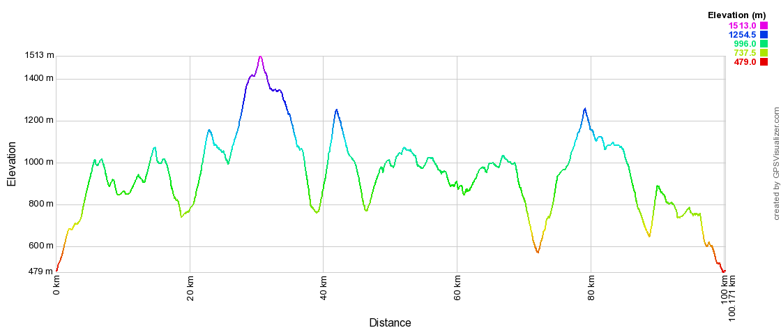
Elevation trail profile - click for enlarge in a new window

GPX file - download
Back to trails list
© 2012 - 2024 Dům dětí a mládeže Pelíšek ve Vrchlabí | contact


